
We are monitoring a range of hazards that may impact our community, including flooding. Stay informed about current issues and restrictions on our hazards dashboard.
We monitor our watershed conditions to track when flooding or droughts may impact our community. We closely monitor key indicators from May to July when we face the highest flooding risk. Some of these indicators include:
- River flows
- Groundwater levels
- Mountain snowpack
- Reservoir levels
- Weather forecasts
- Precipitation
We work with partners and internal groups to understand conditions that could impact our community. Based on conditions, you may see us take actions such as closing select pathways for your safety. We also share current and forecasted conditions during high-hazard season, so our community is informed and can be prepared.
If required, we also have an emergency reponse plan in place to respond in the case of a flood emergency.
We monitor our watershed conditions and will inform you if and when our community is at risk of flooding through social media, our website, and Voyent Alert. Stay up to date with current conditions, and be prepared to act.
- Visit our emergency information page.
- Download the Alberta Emergency Alert app.
- Download Voyent Alert, our direct to text, email, or phone notification service.
- Follow the Town of Canmore on Facebook.
- Check Environment Canada for weather advisories from the Government of Canada.
The Town of Canmore and the Province of Alberta's River Forecast Centre monitor and assess the risks that rainfall and snowmelt may have on rivers and streams in our community. By monitoring the factors outlined above, like precipitation and streamflow, we forecast when potential flood conditions may impact the public and property.
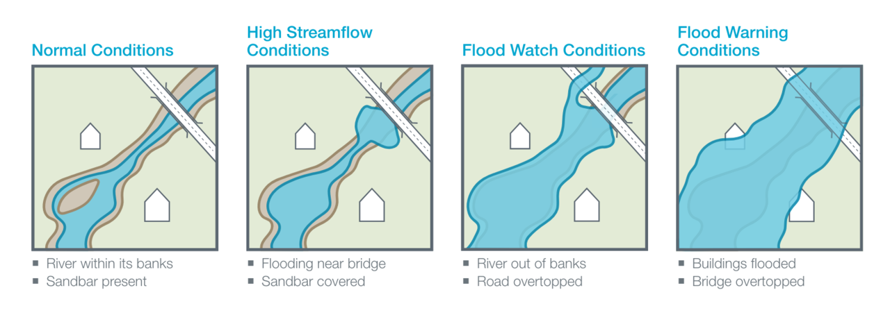
There are five types of advisories that we will use during hazard season (normal conditions, spring run-off advisory, high streamflow advisory, flood watch, and flood alert). When there is an advisory in place for the Bow River or steep creeks like Cougar Creek, we will post them on our hazard dashboard. During hazard high-hazard season in spring and summer, we issue a flood condition update every Monday.
Learn more about what each advisory level means below and explore additional detail about what factors help forecasters determine what advisory to issue.
| Advisory | What it Means | What You Need to Do |
| Normal Conditions | Streams/river levels are within banks and no flooding is expected. | No action required. |
| Spring Runoff Advisory | Streams/river levels are rising or expected to rise due to snowmelt and no major flooding is expected. Minor flooding in low-lying areas is possible. | Anyone situated close to the streams affected (property owners and the general public is advised to be cautious of rising levels). |
| High Streamflow Advisory | Streams/river levels are rising or expected to rise rapidly and no major flooding is expected. Minor flooding in low-lying areas is possible. | Anyone situated close to the streams affected (campers, fishermen, boaters and the general public) is advised to be cautious of the rising levels. |
| Flood Watch | Streams/river levels are rising and will approach or may exceed bank full. Flooding of areas adjacent to these streams may occur. | Anyone situated close to the streams is advised to take appropriate precautionary measures. Be prepared for flooding. Respect any posted closures. Follow any specific direction from the Town of Canmore. |
| Flood Warning | Rising streams/river levels will result in flooding of areas adjacent to the streams affected. | Anyone situated close to the streams is advised to take appropriate precautionary measures. Be prepared for flooding. Respect any posted closures. Follow any specific direction from the Town of Canmore or other emergency officials. |
We can’t prevent flooding entirely, but we can be prepared for when it happens. One of the best ways to be flood-ready is to know your flood risk, to stay informed, and to be prepared to act.