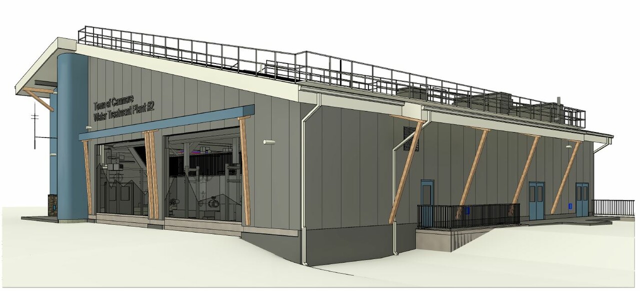
Construction

Because of the 2013 flood event we are a safer community today. It gave rise to a new risk and hazard assessment process, safer steep mountain creeks, and resulted in a robust emergency management plan for future emergencies. While we can’t prevent floods or natural disasters like this, there are things we have done to be safer and better prepared for future floods. In response to the flooding of 2013, the Town of Canmore took the following actions:

  1. Conducted Forensic Assessments and Hazard and Risk Assessments on all priority creeks
  2. Implemented a Seasonal High Water Monitoring Program including annual spring inspection of creeks
  3. Created a Mountain Creek Hazard Mitigation Program (more info below)
  4. Restored the channel on Three Sisters Creek in 2013
  5. Restored the channel on Pigeon Creek in 2014
  6. Restored and armored the channel of Cougar Creek and installed a debris net upstream in 2014, and upgraded culvert at the highway in 2017 
  7. Restored and armored the channel of Stone Creek in 2014
  8. Currently constructing the Debris Flood Retention Structure on Cougar Creek
  9. Updated the Land Use Bylaw to include a Steep Creek Hazard Overlay (section 7.8)
  10. Updated the Municipal Development Plan to include a section on Steep Creeks (section 3.5)
  11. Updated the Engineering Design and Construction Guidelines
  12. Installed weather monitoring equipment at both the Civic Centre and above Cougar Creek

Watch a presentation containing details of all actions above (beginning at 2h:02m).

Mountain Creek Hazard Mitigation Program

The goal of the program is to install infrastructure that protects the community against these potential larger events that may occur in the future. Below you will find the Hazard & Risk Map, as well as information on Cougar Creek, other creeks and other creek resources. 

Hazard & Risk Map - Canmore's Mountain Creeks

This page contains information on the Debris Retention Structure and will be updated on a regular basis during construction - keeping you up to date on impacts in the area. 

Project Update - Sept. 6, 2023

  • While the project has been subject to uncertainty with the need for additional funding to see the project through to completion, work on critical path elements of the project has continued through spring and summer.
  • In August, the Province of Alberta approved a grant of $16.7 million, and on Sept. 5, Canmore Council approved the use of up to $8.3 million in capital reserves to fund the completion of this critical flood infrastructure project.
  • With funding now secured, the project is on track for completion in 2024.

Planned Schedule

Construction will continue through the fall as weather permits and will resume in March 2024 after the winter shutdown. Planned key milestones to complete the project include:

  • Construct approximately 2/3 of the embankment dam prior to winter shutdown.
  • Complete embankment structure, low-level outlet, and spillway by spring runoff season 2024.
  • Complete the project by the end of 2024.

Trail Closures


Please note that Lady MacDonald Trail will be CLOSED as of Sept 11, 2023, for public and worker safety during blasting work. Please respect closures and posted signage for your safety. For details visit Alberta Parks Advisories.

  • The Lady Macdonald hiking trail will be closed as of Sept 11, 2023.
  • Additional short closures impact Montane and Horseshoe Trails. Expect short closures for blasting, any day of the week, usually between 11 a.m. and 3 p.m. Closures will last 15 to 30 minutes maximum. Check Alberta Parks closures for any closures or advisories in place.
  • Cougar Creek Canyon remains closed for the duration of construction.
  • Please respect closures for your safety.

Long-Term Mitigation: Debris Flood Retention Structure 

What will it look like?

  • 34m high rock-filled embankment dam (not constructed out of concrete)
  • Upstream and downstream faces covered by soil and seeded
  • 20m wide rock-cut spillway on the east abutment that includes wildlife egress areas

What will it do?

  • Existing channel and downstream culverts can accommodate 50-60 m3/s, but a natural event on the creek could easily reach 80 m3/s peak flow with 20% debris (fine sediment to large boulders, including gravel and woody debris)
  • The Structure reduces peak flow to 45 m3/s. It further reduces the quantity of debris and removes the larger debris
  • The risk to downstream private and commercial properties, as well as infrastructure, is therefore reduced to an acceptable level
  • There is no water retention during regular operation (dry dam) – water flows freely through a low-level outlet
  • A high-capacity spillway is required to ensure flows can bypass the structure during an extreme flood event

Frequently Asked Questions

What do the construction closures involve?

The closure during construction will impact climbing and hiking in Cougar Creek; all other access to the trails and scrambles in the area will remain open with the exception of blasting closures. Trails that will remain open include Montane, Lady Macdonald, Grotto Mountain, and the Horseshoe loop. Do not attempt to access the closure area at, through, or around the construction sites at any time.

Why are closures being put in place? What alternatives were considered?

The construction closure is to ensure public and contractor safety as well as timely and cost-efficient construction. Alberta Parks and the Town of Canmore considered constructing an alternative route around the closure to access Cougar Creek Canyon. Due to the challenging steep terrain on Lady MacDonald and Grotto Mountain, Alberta Parks determined that closing access is the best alternative for ensuring public safety. 

Is it possible to hike around the closure to access the canyon?

Hiking around the closure to access Cougar Canyon is not permitted. There is a designated wildlife corridor in this area of Bow Valley Wildland Provincial Park and use is only permitted on designated trails.

What environmental studies have been undertaken for the project?

A very comprehensive Environmental Impact Assessment (EIA) has been undertaken for the project. The EIA was followed by three rounds of supplemental information request by Alberta Environment and Parks (AEP). Once the EIA was deemed complete by AEP, the Natural Resource Conservation Board reviewed the project and approved it in October of 2019. The EIA and supplemental information reports, as well as the NRCB review and decision can be found here.

How is the Town ensuring that the best environmental practices are being followed during construction?

The Town has been working with its consultants and Alberta Environment and Parks to create guiding documents for the construction of the project. The two main guiding documents are:

  1. The Construction Environmental Management Plan, that describes principles, best practices and specific requirements during the construction of the project; and 
  2. The Water Quality Management and Monitoring Environmental Protection Plan, that describes the water monitoring requirements during construction of the project.

Moreover, the contractor is required to submit to the Town and its consultants several work plans and environmental protection plans (EPPs) that need to follow the requirements of the guiding documents described above. Examples of plans required for the project: Care of Water work plan, Erosion and Sediment Control EPP, Wildlife and Human Conflict EPP, Invasive Species Control EPP, etc.

Contact Us

For more information on the project email us at cougarcreek@canmore.ca 

Peaks of Grassi (X,Y,Z) Creeks and Echo Canyon Creek 

As of March 2020:

  1. The Town received funding to be able to complete the hazard and risk assessment of X, Y, Z creeks (above the Peaks of Grassi) and Echo Creek Canyon (near Alpine Club of Canada).
  2. A consultant was awarded the contract on April 2, 2018. 
  3. Field work was completed in May and June of 2018.  
  4. Council was presented with the results in January of 2019, followed by a public presentation with Q&A session. Read the  Echo Canyon Creek Hazard and Risk Assessment (19.44 MB)  or the XYZ Creeks Hazard and Risk Assessment (37.93 MB) .
  5. The options may be considered by Council and Administration as work on higher priority creek areas is completed.

Stoneworks Creek

As of March 2020:

  1. The design of the Stoneworks Creek long-term mitigation phase 1 is complete. This first phase of mitigation is to protect existing development.
  2. Construction was contingent on a successful Alberta Community Resiliency Program (ACRP) grant application. The grant was not approved in advance of cancellation of the ACRP program.
  3. The project funding model included approximately $800,000 in Disaster Recovery Program (DRP) funding to restore the previously damaged mitigation. DRP spending had to be completed and costs submitted to the province by June 2019 to be eligible. Administration negotiated with DRP to allow for the procurement of rock materials (rip rap) required for the construction of the long-term project with the DRP funds available. The material was stockpiled on site in May 2019. This work represents approximately 20% completion for Phase 1.
  4. To allow for future development of the Stoneworks Creek fan, including Town-owned lands, a second phase of long-term mitigation has been planned. This Phase 2 work would build on mitigation required for existing development. Mitigation of new development is not eligible for grant programs, and therefore funding for this work is expected to be a requirement of future developments.
  5. Depending on timing of funding and development, both phases of work may be combined in the future for efficiency.

Three Sisters Creek

As of March 2020:

  1. Flood rehabilitation and mitigation of the lower reach of Three-Sisters Creek, between the Bow River and the pedestrian bridge was substantially completed in September 2018. The work consisted of:

    a)  Armoring of the creek banks damaged in 2013 with large rock rip rap placed in an interlocking manner (stone pitching)
    b)  Stone pitching of the pedestrian bridge abutments and a small section of creek bank upstream of the bridge
    c)  Removal of some trees directly upstream of the pedestrian bridge to minimize future culvert and bridge blockage issues 
         by trees
    d)  Adding a missing lock block directly upstream of the parkway culvert
    e)  Stone pitching a section of the curved bank downstream of the parkway culvert
    f)  Re-seeding the area with deep rooted grasses to increase resiliency  

  2. Minor landscaping work will take place in 2019.

  3. Design of long-term mitigation for the upper reach of Three-Sisters Creek will commence after the hazard and risk assessments are updated.

  4. Three Sisters Mountain Village (TSMV) is currently assessing the steep creek hazard in relation to future development on the western portion of the fan. Their updated assessment will also inform updates to the Town’s long-term mitigation plan for Three Sisters Creek. Coordination between the Town and TSMV will ensure areas developed on the fan meet policy requirements.

  5. Construction of long-term mitigation was identified for a 2022 start in the 6-year capital plan Council included in the approved 2020-2021 budget.

Other Creeks

As of January 2018:

  1. The hazard and risk assessment of Stones Canyon Creek will be completed by end of 2018.
  2. A private developer has undertaken the studies of the Smith Creek area.

Pigeon Creek

As of March 2020: 

  1. All the work involving the Town of Canmore is now complete. This includes the hazard and risk assessments, as well as the Option Analysis.
  2. The short-term mitigation work, led by the MD of Bighorn will be completed by summer 2018. 
  3. The MD of Bighorn might wish to undertake long-term mitigation to reduce risks to its development, and TSMV will need to consider long-term mitigation when development in the Smith Creek area progresses. 

Stone Creek

As of March 2020:

  1. Construction of long-term mitigation works is planned for 2025, pending further grant availability and subsequent Council approval.
Rendering of New Fire Hall

In 2019, Council approved a plan to construct a new 8-bay fire station in the Palliser area (near the intersection of Palliser and Benchlands Trails). 

Construction Impacts - Updated March 21, 2023

  • Construction on the fire station is underway and is anticipated to be completed by early fall 2023.
  • The cemetery remains open during construction. 

Background Information

The current fire hall located at the corner of Railway Avenue and 10 St. was built in 1986, at a time when the population was approximately 4,000. With our current population and tourism numbers, the facility presents challenges to the ability to fully serve fire and rescue service needs and there is no capacity to accommodate future growth.

Given its importance to the community, especially during community-wide emergencies, finding the most appropriate location requires careful analysis. Funding was approved in the 2018 budget to conduct a study to determine the most appropriate location(s) needed to provide fire and rescue services in Canmore over the long-term. The Fire Hall Study recommendation is that two fire halls with 12 apparatus bays are needed to provide fire and rescue services in Canmore over the long-term.