
What's Happening
We are making routine road repairs along Fairholme Drive between 17 Street and 10 Street between Sept. 15-Oct. 17, 2025. The upgrades include concrete repairs to sidewalks, accessibility ramps, and curb and gutters, and road milling and repaving.
What You Need to Know
- Expect delays during construction, including alternating one-way traffic during paving operations
- Follow detours
Learn More
Learn more about our work to make it easier to get around Canmore.
For questions, reach out to our Engineering team.
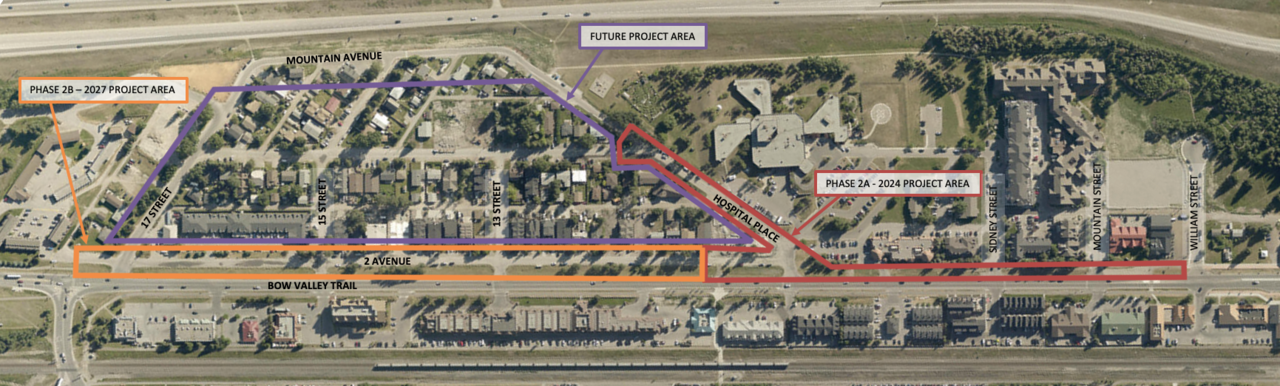
We are working on transportation improvement projects in the Bow Valley Trail & Teepee Town areas to make it easier for people to travel safely in these communities.
Phase 2A (2024/5) - Bow Valley Trail East and Hospital Place
This phase of the project is complete. The upgrades included:
- Replacement of underground utilities.
- Improving drainage.
- Extending separated cycle and pedestrian pathways from Williams Street to Hospital Place.
- Adding new bus stops to support the Grassi Lakes transit route.
- Making ignificant improvements to Bow Valley Trail crosswalks.
Phase 2B - 2 Avenue (forecasted for 2027)
The scope of work includes:
- Replacing/rehabing underground utilities.
- Making improvements to the street and sidewalk on 2 Ave from the end of Phase 2A to 17 Street.
- Adding raised intersections at 13 St/2 Ave and 15 St/2 Ave.
- Improving drainage adjacent to Bow Valley Trail.
Learn More
For questions, reach out to our Engineering team.
What's Happening
In spring 2025 we are increasing trail connectivity on Elk Run boulevard near Cougar Creek to enhance user experience and to create a safe, efficient, transportation network for all users.
What You Need to Know
Expect minor traffic disruption on Elk Run (potential one-way alternating traffic for short period of time) in addition to the temporary closure of the Cougar Creek hockey rink parking lot during construction. We expect that the project will wrap up at the end of summer 2025.
Learn More
Learn more about our work to make it easier to get around Canmore.
For questions, reach out to our Engineering team.
Railway Avenue is one of Canmore’s busiest transportation corridors. It’s due for underground utility upgrades, and at the same time, we’re redesigning the street to better support walking, cycling, transit, and vehicle traffic. This work follows the goals in our Integrated Transportation Plan.
Project Background
We’re improving Railway Avenue in phases:
- Railway Avenue South (Bow Valley Trail South to Elevation Place) was completed in 2021.
- Railway Avenue Central Phase 1 (Elevation Place to Main Street),
- Railway Central Phase 2 (just south of 10 St. to Birchwood Place)
- and Railway Avenue North (Birchwood Place to Bow Valley Trail North and portions of 17 St.) are planned for future construction
Project Goals
- Give people more options for getting around — by foot, bike, transit, or car.
- Build a street that works for everyone, including delivery trucks and emergency vehicles.
- Support the goal of 40% non-vehicular travel during peak times like long weekends.
- Help people move into and around the Town Centre more efficiently.
Current phase of work: Railway Ave Central
This phase runs from the CPKC rail crossing at Elevation Place to just north of Main Street. The scope of the Railway Avenue Central phase focuses on Main and 10 Street intersections and connects through new pedestrian and cycle facilities to the north and south sections of Railway.
What’s Changing?
We’re redesigning the intersection at Main Street and Railway Avenue with a protected intersection, similar to what you see at the Shops of Canmore. This safer design will make it easier for pedestrians and cyclists to cross.
We’re also improving connections to pedestrian and cycle routes south of Elevation Place.
Detailed Designs:
Railway Avenue Concept Design - Elevation Place to Main St.
Railway Avenue Concept Design - Main St. and 10 St.
Railway Avenue Detailed Design Cross Sections
Railway Ave Detailed Design Geometry
Learn More
You can find detailed designs, cross sections, and a summary of past engagement on the MyCanmore project page.
Frequently Asked Questions
The transportation design engineering meets current best practices and adheres to professional standards and guidelines. These standards and guidelines include emergency vehicle access requirements and emergency evacuation requirements.
During construction, traffic will be managed under a traffic plan. Construction methods include mostly trenchless water and sanitary main rehabilitation which will significantly reduce traffic impacts.
We’ve completed concept designs to expand the Elevation Place parking area. However, there's no construction planned at this time. We're still exploring other options, but we are limited available land.
The goal is to improve the entire transportation network for all methods of travel. Better connections, more direct routes, and safe designs make it easier for people to choose walking or cycling which increases the overall capacity of our network. We’ve already seen remarkable increases in active travel when improved infrastructure makes it more attractive.
Will a reduction in lanes results in traffic delays?
You might see slight delays during busy times in the short term. But not taking proactive measures will cause even more congestion in the future. This redesign helps manage long-term traffic and makes travel better for everyone. Learn more about our work to keep people moving in Canmore over the long-term.
Questions
Have a question? Reach out to our Engineering team.